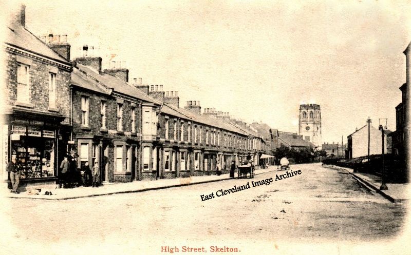
This undated post card view of the lower part of Skelton High Street shows a conical hay stack on the site of the modern-day Sterne Cottages. A. E. Fox comments: “The last house on the right, 27 High Street, was my family home from 1941 until 1953. My Grandmother (Mary Anne Dixon) died there in 1955, my mother moved to the South of England and I went to Boarding School in Berkshire. My uncle (John Dixon) and his family lived at 27; having moved from Loftus and later moved to a new bungalow Marske. Number 27 was then sold. My other family members, Frank and Marion Berwick lived just below the junction of Marske Lane and the High Street where they operated a Joinery business.” Kenneth Hannah adds: “My family moved in to the cottage in the lower right hand corner (30 High Street) in December1956, and stayed until May 1967 when we moved to Kilton Mill.” Maxine Bell comments: “We have moved into Rose cottage (30 High Street) recently. My Husband has being cutting back the hedge to stop the sandstone wall from falling down. We were both surprised that after years of growth an old coal bunker was revealed it was actually built into the wall. Can anyone shed any light on this. I would love to know the history of my home.”
Image courtesy of Olive Bennett and Peter Appleton, thanks to A. E. Fox, Kenneth Hannah and Maxine Bell for the updates.
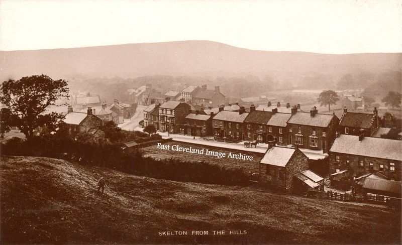
A postcard view looking eastwards along Skelton High Street, the houses on the south side beyond the Co-op building have not as yet all been completed. Peter Appleton has assisted with this information: “This image possibly is dated to between 1901 and 1911. In the 1901 census, the southside properties are pretty much as shown here. By 1911, most of the south side had been built. In November 1911 the Estate applied for planning permission to build three cottages to fill the remaining gap. These three cottages can be identified, even today, by an observant pedestrian. The secret is to study the lintels over the first floor windows. Those of the last three are of a slightly different colour of sandstone.” The Archive has since seen the post card, it being postmarked September 1906.
Image courtesy of Peter Appleton and Olive Bennett; many thanks to Peter Appleton for the update.
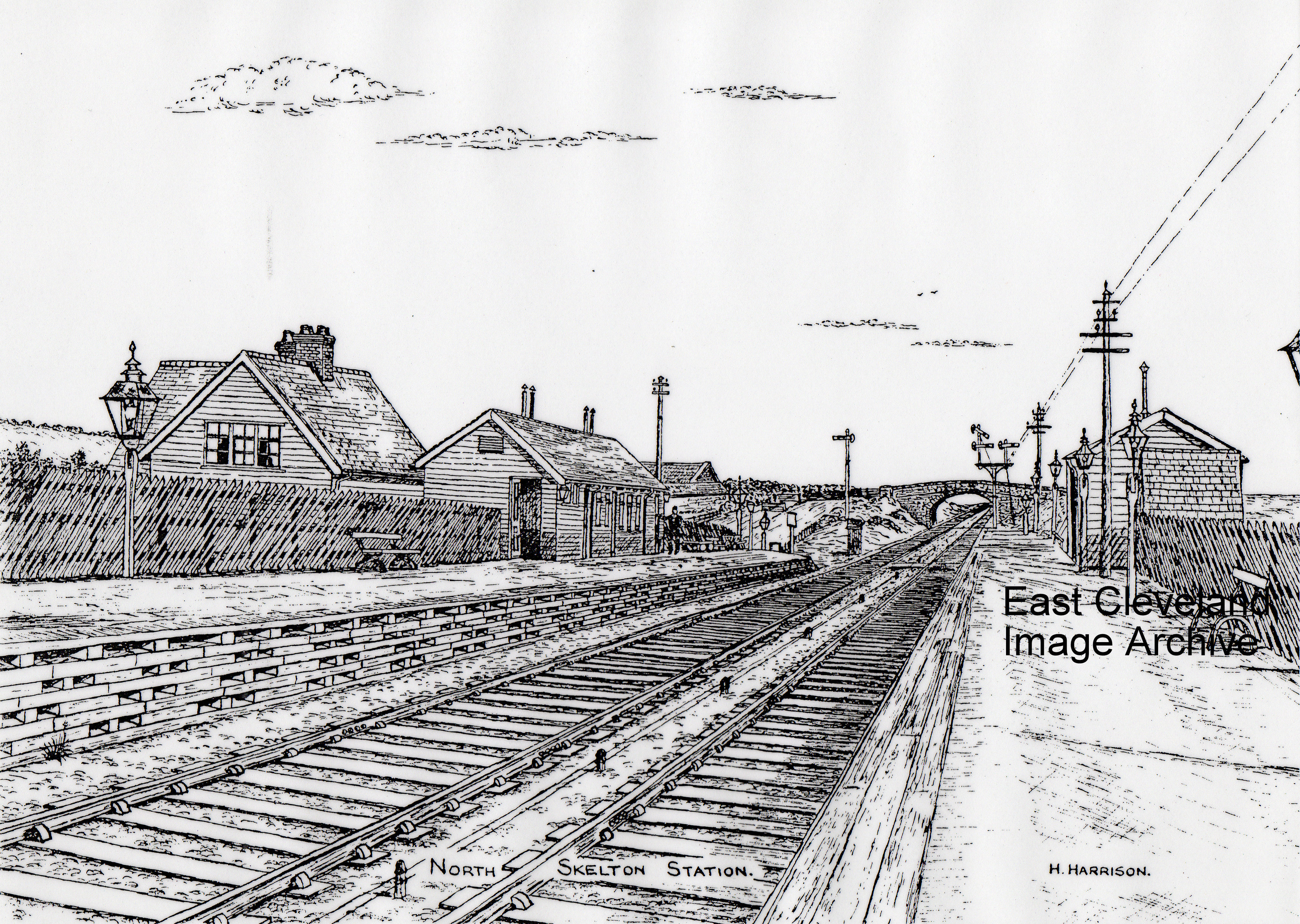
Skelton station as we have never seen it, once again a lovely drawing, the station was South-East along the railway from Hollybush Bridge. David Richardson tells us: “It opened on 1st July 1902 and was closed to passengers on 10th September 1951; closing completely on 21st January 1964. The building to the left of the picture was the Station Masters house which still stands. Derick Pearson assisted with: “North Skelton Station was at Hollybush where Wilkinson Brothers Car Breakers yard is sited.” Locals can remember some platforms still being there and we believe this is the one depicted in the etching. Stonehouse Brothers had the yard for coaches before Wilkinson Brothers; a little further along the line was Long Acres Pit which is also shown on site.
Image courtesy of Joan Webster and thanks to David Richardson and Derick Pearson for updates.
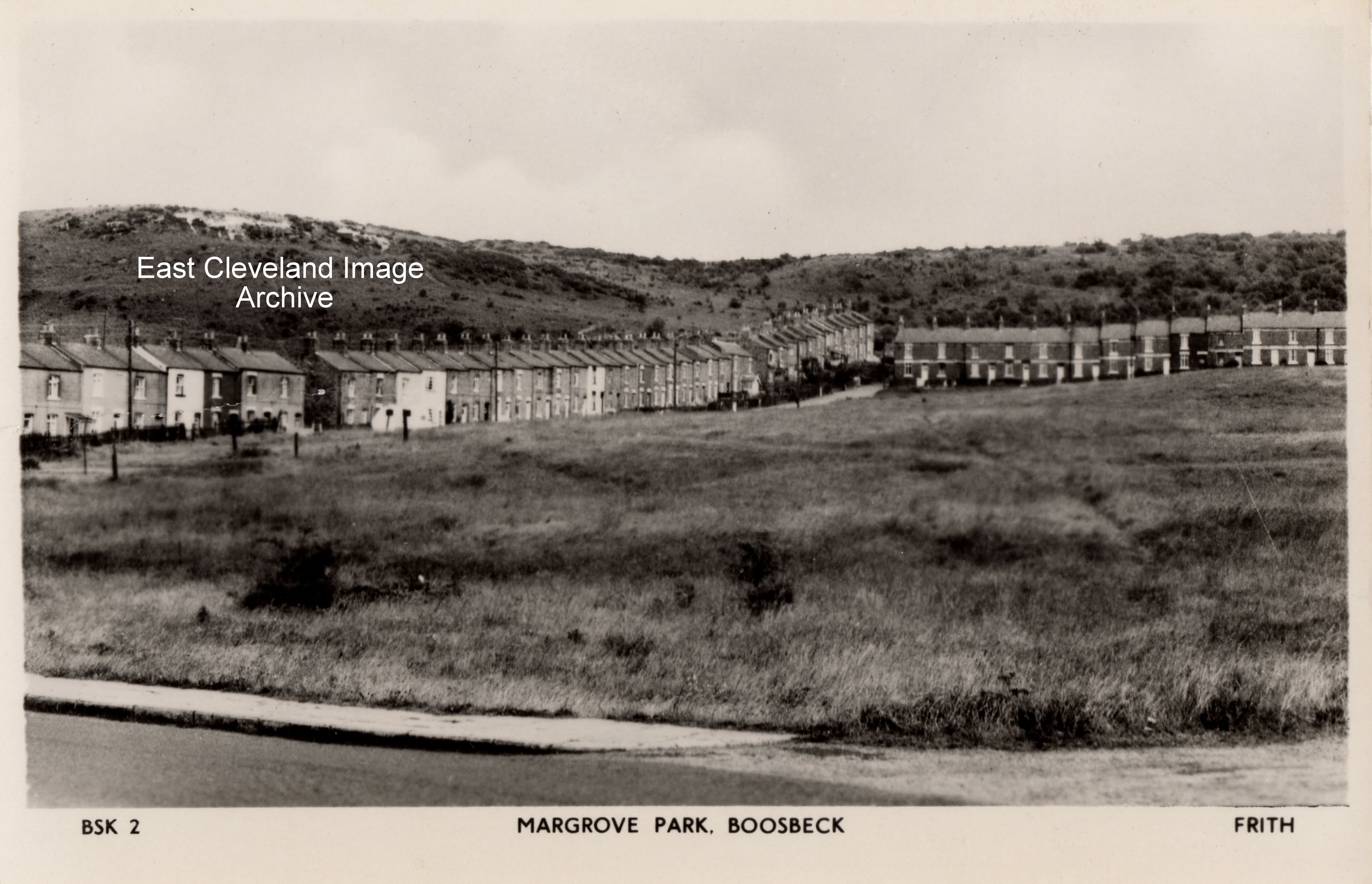
More familiarly known as “Magra” this Frith postcard is believed to date from the 1950s and is the best image as yet available to the Archive. This small community developed as a result of South Skelton ironstone mine being built in the 1850s and originally consisted of the two terraces of houses forming an L-shape on the hillside; between 1928 and 1933 Margrove and other local communities was closely linked to the Heartbreak Hill initiative by the Pennyman family of Ormesby Hall. The aim being to assist the residents whose lives had been devastated during the Depression; more recently this believed good works may have been had links to Nazi ideals and is still open for debate.
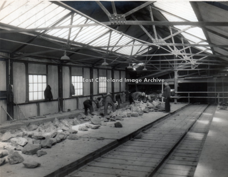
A typical scene on the picking belt at an ironstone mine in Cleveland. Here the shale was seperated from the ironstone as it came from the mine, larger lumps are being broken up by sledge hammers. Bill Danby tells us: ”My brother in law, Frank Holmes, who was a Deputy at both Lingdale and North Skelton Ironstone Mines says that this photograph is most likely Lingdale. North Skelton did not have a “belt”, as there so little shale content in the ore extracted from that mine, whereas at Lingdale the shale content was high. Hence the man-made mountain that used to stand behind Coral Street. South Skelton Mine, he adds, also had a “belt” but it was on a slope.”
Image courtesy of George Pearson and many thanks to Bill Danby (and Frank Holmes) for the update.
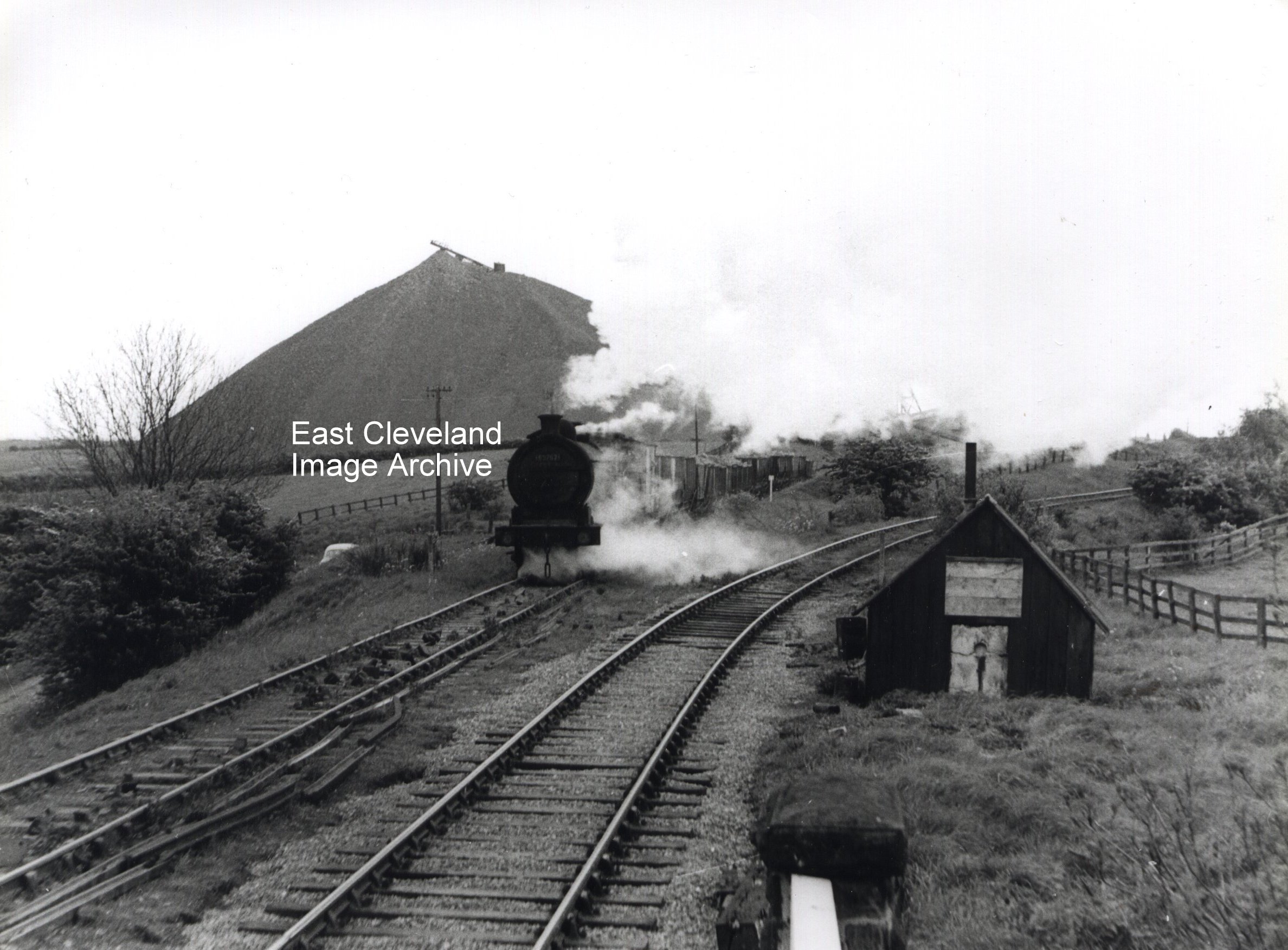
Taken about 1957 of a loaded train from Kilton Mine approaching Lingdale Junction; the Lingdale Mines branch is the one curving to the right and was extremely steep. Simon Chapman told us: “Look carefully at the train and you’ll see the brake van is behind the engine, not at the back of the train. This was allowed in later years because the gradient was down all the way to Brotton, where the engine ran round to reverse the train before taking it to Tees-side. In place of the brake van at the end of the train a lamp or red flag was hung on the back of the last wagon to show to signalmen at Kiltonthorpe Junction and Brotton that the train was complete i.e. a wagon hadn’t been derailed and lost on the way.” Also of interest is the shale spoil ‘hill’ on the left of the image; this is now one of the few remaining hills of excavated spoil from the ironstone mines of East Cleveland; South Skelton being another such reminder. Alan Featonby suggests: “It is possible this photograph was taken on 21st May, 1959. A similar photograph appears in ‘Stephen Chapman’s book Railway Memories No. 18 Cleveland and Whitby’ attributed to Ken Hoole. If so, the locomotive is Class J26 65762 of Thornaby shed. The car by the coal drops is the give away.”
Image courtesy of the Pem Holliday Collection and many thanks to Simon Chapman, Peter Appleton and Alan Featonby for the updates.
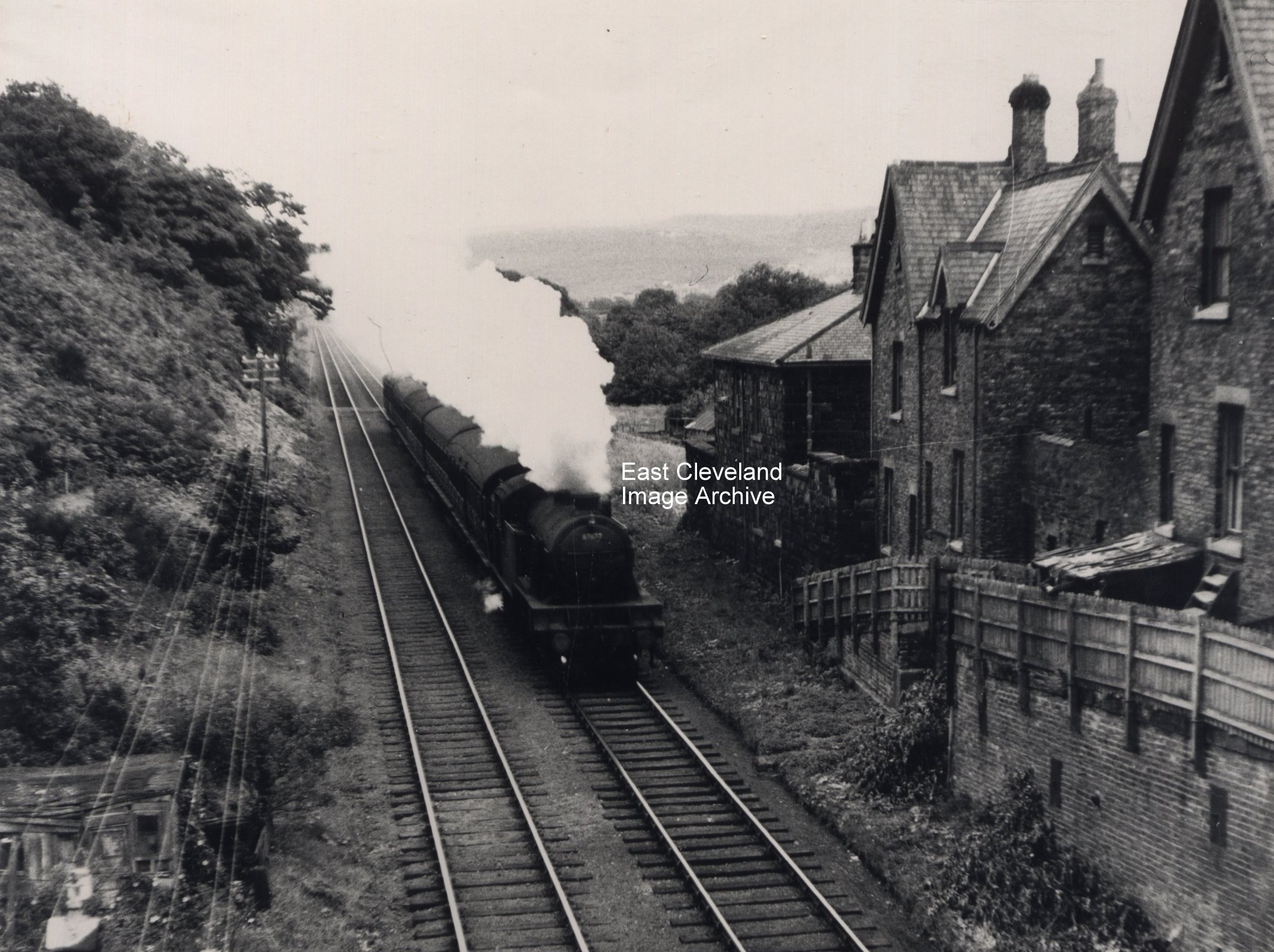
Taken from the old road bridge that carried the A171 over the railway at Slapewath (the scene of many minor bumps in the distant past), the picture shows the backs of the houses at Slapewath. The train is approaching Spawood junction from Boosbeck. It’s difficult to visualise this view now as the A171 re-alignment was so major, I seem to remember two bridges, one over the railway, one over the beck and one rail bridge over the road (to South Skelton or Park) pit) at Fancy Bank (the remains of the railway can be seen on the hillside as a gated forest road). Some of the remains of the old road and rail structures can be seen with the beautiful viaduct at Spawood (now becoming enshrouded in trees) and the road bridge over the beck adjacent partly covered by the modern A171 as it sweeps down Fancy Bank. I think the locomotive is numbered 67678, which would make it a V3 2-6-2T, but it’s not an easy one to see.
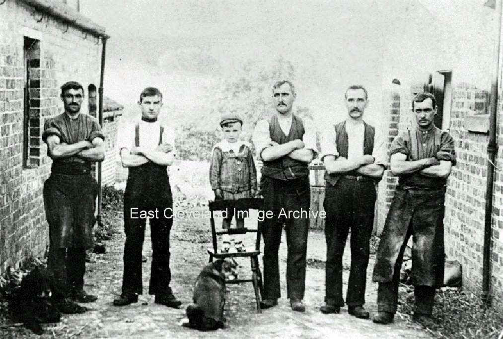
A quirky image by modern standards, but typical of the type of narrative image that occurred in early photography. Alfred Wither (left) blacksmith for Spawood and South Skelton Mines with his striker (right) and stable-hands, an indispensable part of the iron mining industry, they made and maintained just about every tool in use in the mine. Just who the well-dressed little boy is in the middle I do not know – can anyone tell me please?
Image courtesy of Cleveland Ironstone Mining Museum.
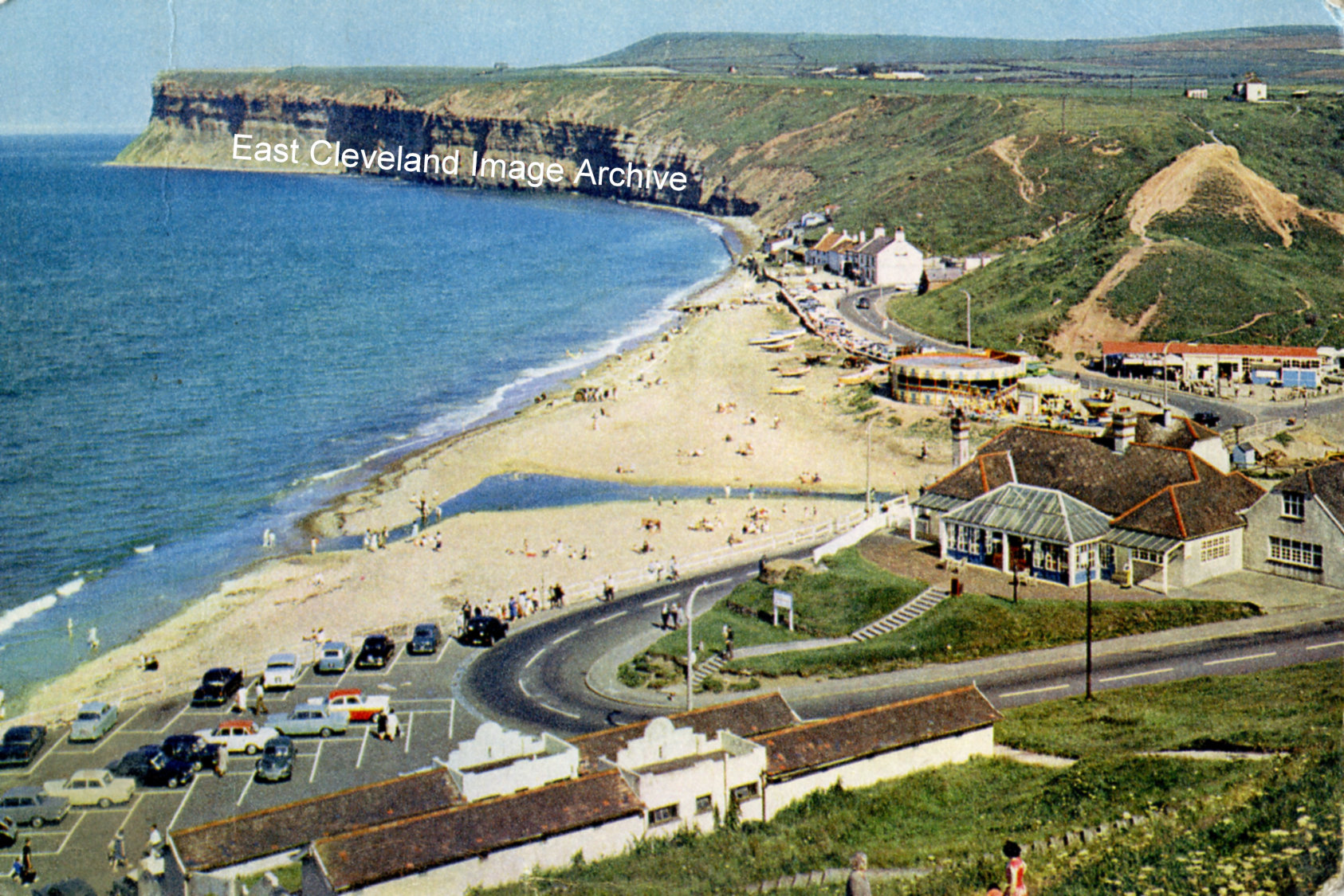
The caption that is printed on the reverse of this postcard reads: ”Old Saltburn, Yorkshire. At the foot of the valley through which Skelton Beck reaches the sea, Old Saltburn’s few cottages are so close to the breakers that spray beats on the windows. The headland of Huntcliff to the south forms a fine background.” David Richardson commented: “This may have been taken in the 1950’s.”
Image courtesy of Tina Dowey, from a postcard that was published by J. Arthur Dixon, Ltd; thanks to David Richardson for the update.
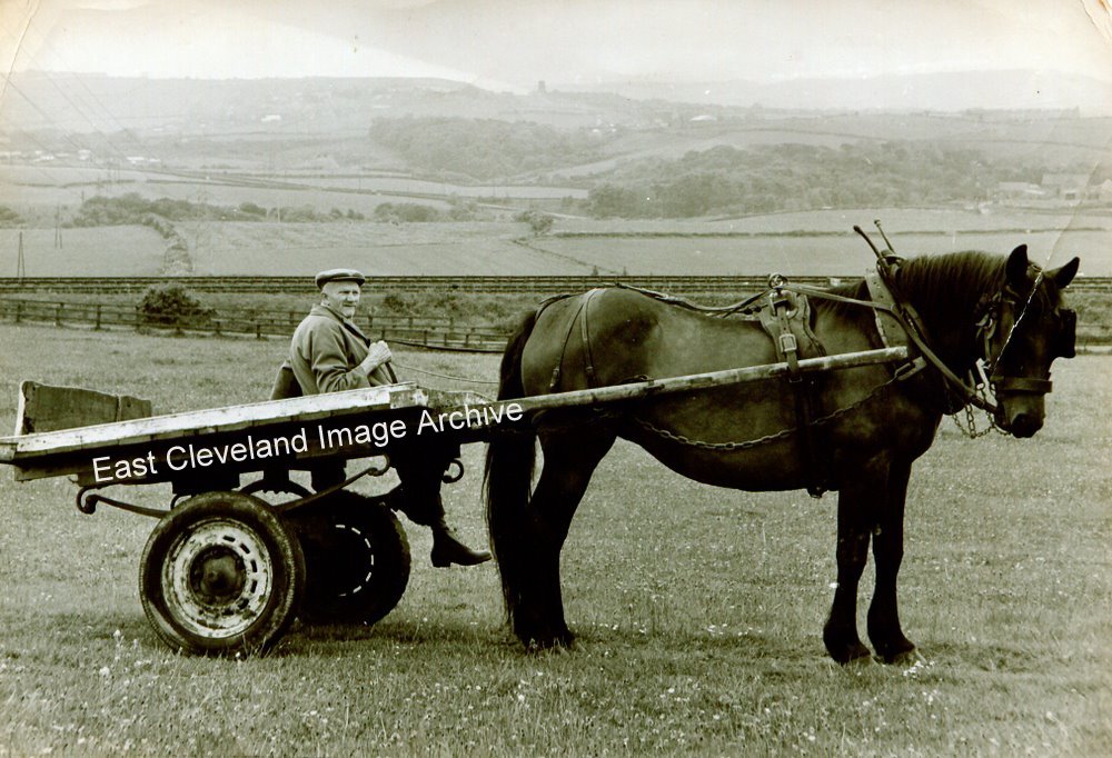
Derick Pearson told the Archive: “My grandfather on the old cart in Lumpsey fields. Looking toward North Skelton on extreme left and with Skelton church tower dead centre on horizon. This was Lady Dolly in the shafts, she was a pleasure to work with. Cleveland Bays were multi-purpose horses, they could hunt, do point to point and were tremendous workers. Size for size, they took some beating. My grandfather in this photograph was about 78 years old and had spent a lifetime with horses. He finally achieved his dream when his champion (Chapman) was purchased by the Queen, who’s buyers came to see them at Brotton. He won a Professorship and Title with the Berry School of Horsemanship in Ohio USA in 1912. The certificate is still in the family. He was one of only two people in England to ever win it by correspondence and was booked to go to Ohio on the Titanic from Southampton in 1912. Circumstances prevented him from going. How fortunate, I may never have been here to tell the tale had he gone at that time. Another thing worthy of mention is that the original Cleveland Bay was called a Chapman. It was a tinkers or pot, pan and knife sharpeners horse. Those travelling people were called Chapman’s in times of old, hence the name which was attached to the breed. Grandad was always proud of this, saying these horses were named especially for him and that is why he named his champion ”Chapman”.
Andrew Pearson (no relation) adds: “Unrelated but for the record – the railway line in the background is the one that ran from Brotton Junction to Middlesbrough via Claphow bridge, Boosbeck, Guisborough and Nunthorpe and in this photograph it looks to be no longer in regular use; unfortunately there is no date but it was part of the coast route to Whitby which closed in 1958 and finally dismantled in 1965 between Brotton and the junction with the Esk Valley route, following cessation of service to the public delivery siding at Boosbeck in 1964. The other line from Brotton to Saltburn runs parallel with it but cannot be seen at this point as it is now at a lower level, making its descent in a wide sweep towards Skelton and Saltburn where it joins the Saltburn – Redcar – Middlesbrough line; this is still very much in use for the Skinningrove and Boulby Potash traffic. Also, the site of Lumpsey Mine is out of the picture to the left.”
Image and information courtesy of Derrick Pearson, thanks also to Andrew Chapman for the additional information.
Recent Comments