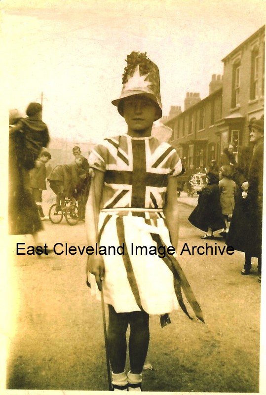
Joyce Hore in Lumley Street, Loftus; all dressed up, for the Coronation celebrations in 1937.
Image and information courtesy of Joyce Hore.
|
|
||
|
Joyce Hore in Lumley Street, Loftus; all dressed up, for the Coronation celebrations in 1937. Image and information courtesy of Joyce Hore.
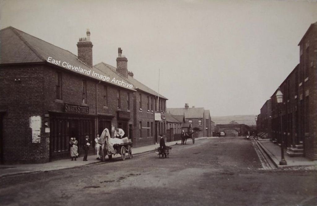
This view of Vaughan Street, North Skelton dates from about 1906; it is from a used postcard bearing that date. The original village hall is today replaced by a more modern building, whilst “Smarts Stores” is now the location of ‘Curly Tops’ hairdressing salon. However I would not suggest trying to stand with a wheelbarrow in the middle of the street today; traffic is more prolific and moves at a faster pace that then. Judy Last advises: “My grandparents Albert and Emma Tuck, ran Tuck & Thompson’s Grocers/Drapers (later Smart’s Stores) at 27 Vaughan Street and my grandfather was postmaster from about 1895 or before until 1901. My father, Alexander Tuck, was born above the shop in 1897. I know that my great grandparents, Edwin and Grace Tuck had a Grocer’s shop in Boosbeck by 1877 and had connections with North Skelton as well, so they may have owned the shop in Vaughan Street” Peter Appleton adds information with: “I was alerted a 4d Tuck& Thompson token by the property owner, who was doing some renovation work. Tuck & Thompson had a grocery business in North Skelton. I am presuming that this would have been part of a miner’s wages and could only be redeemed in Tuck & Thompson’s shop. An attempt to ensure that the miner didn’t spend all his earnings on the three B’s (booze, baccy and betting).” Image courtesy of The Pem Holliday Collection and Derick Pearson, thanks also to Peter Appleton for the information on Tuck & Thompsons token system.
How things change! This view from Grove Road over the allotments gives a view of the back of the Co-operative building (now finally gone!), Hutton Street shops are no more, today even the allotments are gone. But the new houses on the High Street are clearly visible, can any one assist with a date? Image courtesy of the Pem Holliday Collection. 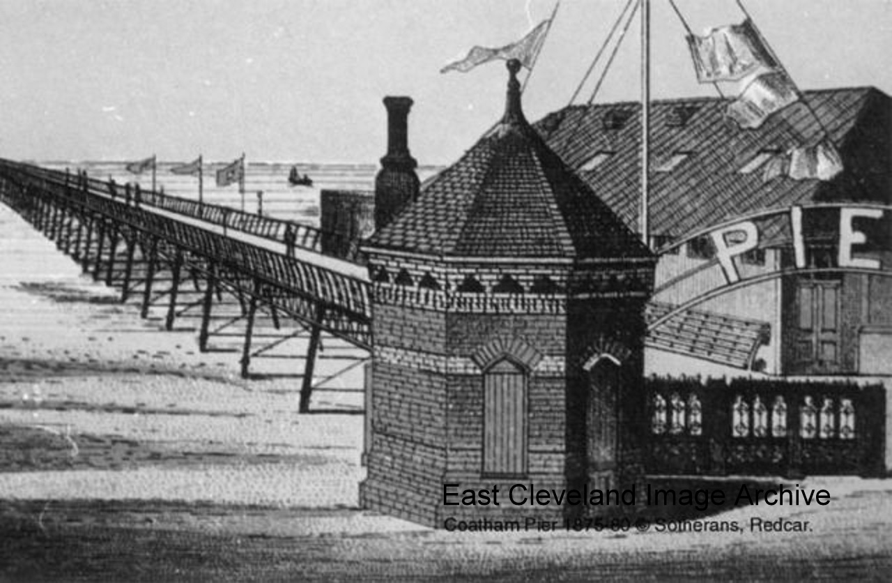 Another lovely pier long gone; the Archive now has further information on this pier from: ‘Yorkshire Piers’ author Martin Easdown. He tells us ”Coatham Pier had actually opened to the public in 1872 and was fully completed in 1874 to a length of 2,250ft before it was hit by the ‘Griffin’ and ‘Corrymbus’ in December 1874. The pier was repaired but was wrecked by storms in December 1876 and was shortened to 1,770ft. The pier was demolished in 1899 after being cut in two by the ‘Birger’ in October 1898.” Image (from a postcard produced by Peter Sotheran) courtesy op Mike Holliday, thanks to Martin Easdown for the update. 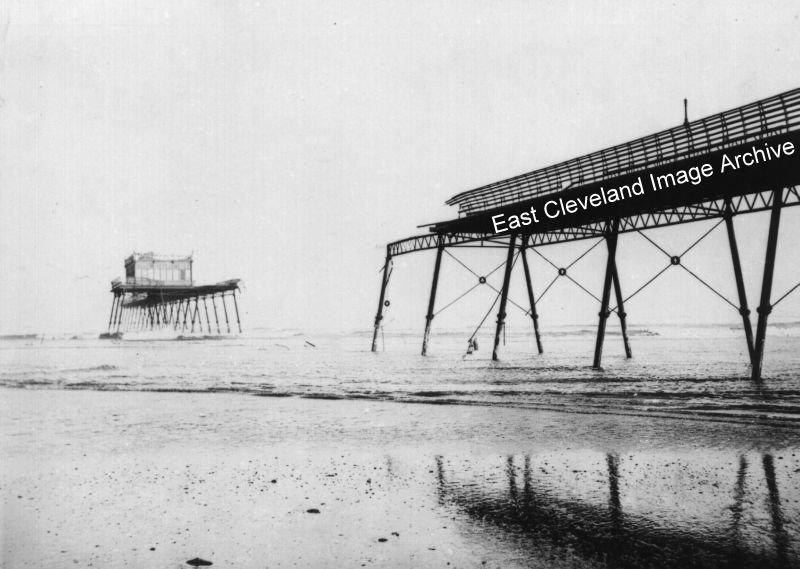 Now the way I look at this it is Coatham pier cut in two, do you agree? How great Redcar would have looked today with two magnificent piers. Fred Brunskill advises us: ”Originally Coatham Pier was to be much longer than Redcar pier with a glazed ballroom pavilion in the centre. Unfortunately before the seaward side of the pavilion could be completed it was breached in 1874 by the brig ‘Griffin’ and had to be abandoned. During the same storm the ‘Corrymbus also breached the pier causing much more damage. The final straw was in 1898 when the Finnish barque ‘Birger’ tore out a hundred yard section leaving the pavilion isolated. Repairs were too costly and the the pier was partly dismantled and left for many years. Not being able to meet their debts the Pier company ceased trading the following year.” Rev. Neil McNicholas asks: “On p11 is a picture of Redcar Pier with, as you can just make out, criss-cross bars underneath – as in this picture. So is this Redcar Pier rather than Coatham?” Further investigation reveals that above the cross-bars there are smaller cross-bars on the Coatham pier. Image courtesy of Mike Holliday, thanks to Fred Brunskill for the update and to Rev. Neil McNicholas for the enquiry. 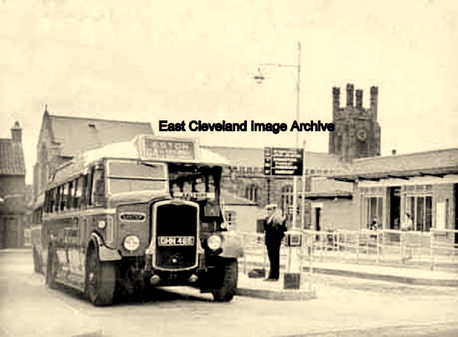 Do you remember Redcar bus station like this? I do. Tony Chambers tells us: ”I to remember the bus station; it was on the left at top of High Street coming in from Marske side. I was born in Redcar (1947) and left when I was 10 years old. I can remember the cinema behind or very near the clock tower. There was a children’s clinic next to cinema where we had to go each week for a spoon of thick orange juice (tasty!). The Library right side of clock on corner. Marks and Spencer’s a little further up the High Street on left of clock. King’s Ice cream on the coast road near Zetland park. I can go on and on. I have not been there since around 1961.” ” Peter Dale has memories of the Redcar bus station: “Now a car park! Quite often the buses would run away backwards, towards Lord Street, crossing the road and ending up in the Granby Café (Later to become Redcar Citizen’s Club) or the cottage next door; wooden blocks were chained to the railing stanchions at each bus stand to prevent this happening.” Image courtesy of Mike Holliday and others, thanks to Tony Chambers for the additional information on Redcar, also to Peter Dale for his update. 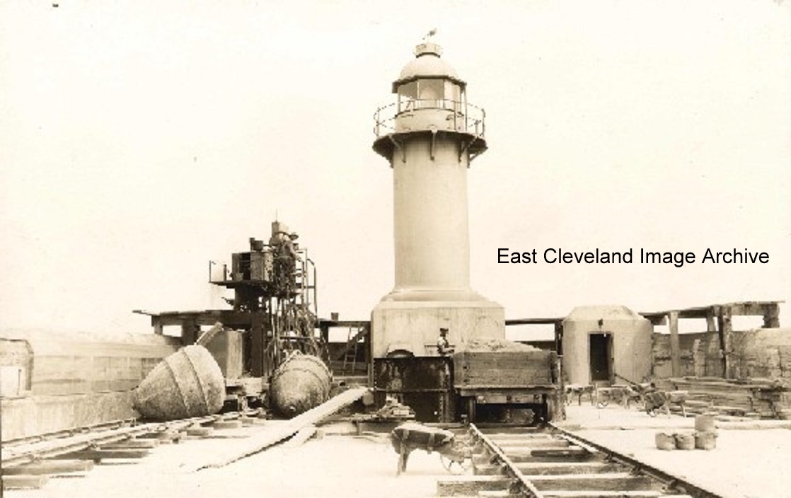 Opened in 1888 the Gare is two and a half miles long and cost £219,300 to construct of slag provided by the local ironworks who also contributed to the transport costs. The Stockton & Darlington Railway Company constructed a line from the blast furnaces at Cargo Fleet to the Tees Conservancy Commissioners’ Railway at Tod Point to transport the slag. During the opening ceremony of the South Gare the line was put to an unusual use as trains from Middlesbrough took special guests to the base of the lighthouse. Later, as there were no trains running on the track, workmen boarded a flat bogey propelled by a sail. Other images of the sail trains can be seen on the Archive. Image courtesy of Mike Holliday, information courtesy of ”South Gare” a Cleveland Urban Fringe Scheme publication. Also featuring in ‘Lighthouses of the North East Coast’ by Robin Jenkins. 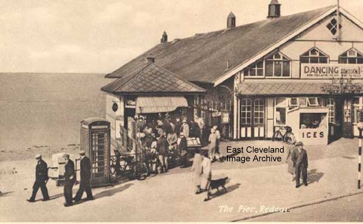 I remember this too and many happy hours here dancing. The beautiful pier has gone and all that remains is this building. The image taken it is believed from a postcard is possibly from the late 1940s or 1950s. Callum Duff advises: “There doesn’t look like there’s any structure beyond the shore end of the pier so late 1940’s – early 1950’s is a reasonable estimate. This is a photograph of Redcar Pier Pavilion which was completely demolished in 1981 and not to be confused with The Regent Cinema, built over the entrance of Coatham Pier which is currently being re-developed.” Alan Franks tells us: “I used to go here in the mid 1950s when I lived at Redcar as a young teenager; five Woodbines between two of us a lemonade and a glance from a girl we fancied and we went home happy.” Image courtesy of Mike Holliday, thanks to Callum Duff for the update and Alan Franks for the memories. 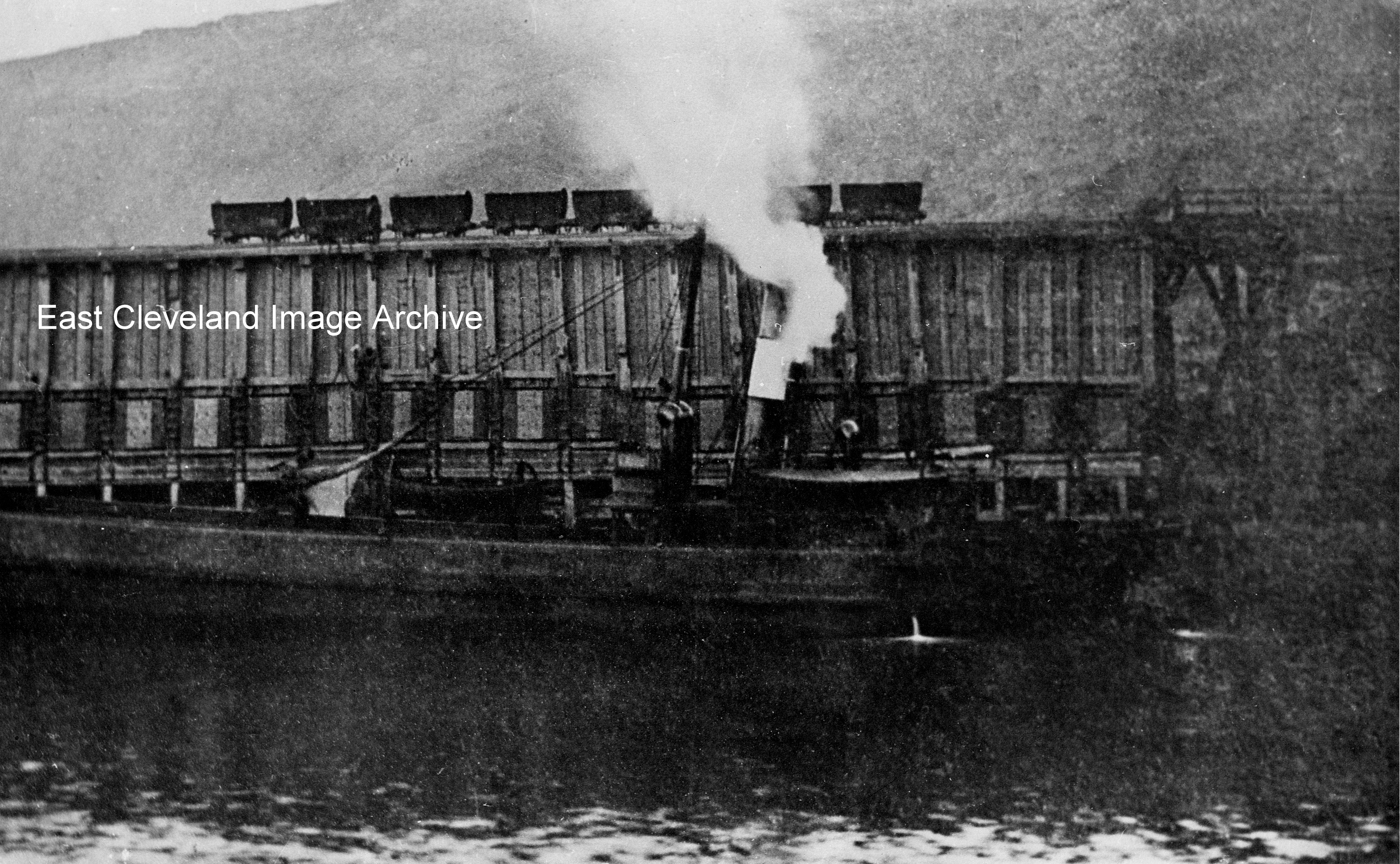 A view of Palmers ironstone loading staithes at Port Mulgrave, with a boat either just berthing or about to depart (judging by the smoking chimney stack!) from the jetty. Bill Danby advised: “This is another shot of the jetty at Port Mulgrave. If you look at the photograph entitled “Port Mulgrave” with boats waiting to be loaded, you can see the structure of the jetty is the same and in fact this is virtually the same scene taken from another angle.” Image courtesy of Maurice Grayson and thanks to Bill Danby for the update. 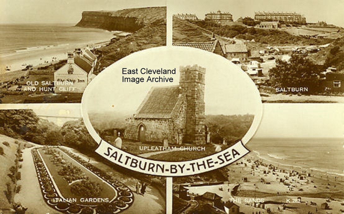 We don’t see many photographs of Upleatham church, appearing on a postcard of Saltburn as one of the local scenic beauties. Image courtesy of Mike Holliday. |
||
Recent Comments